


Forest Lakes Voting District, Coconino County, Arizona
About
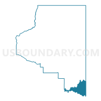
Outline

Summary
| Unique Area Identifier | 523748 |
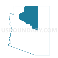
| Name | Forest Lakes Voting District |
| County | Coconino County |
| State | Arizona |
| Area (square miles) | 598.15 |
| Land Area (square miles) | 597.37 |
| Water Area (square miles) | 0.79 |
| % of Land Area | 99.87 |
| % of Water Area | 0.13 |
| Latitude of the Internal Point | 34.51002270 |
| Longtitude of the Internal Point | -110.96089700 |
Maps

Graphs
Select a template below for downloading or customizing gragh for Forest Lakes Voting District, Coconino County, Arizona


Neighbors
Neighoring Voting District (by Name) Neighboring Voting District on the Map
- Blue Ridge Voting District, Coconino County, AZ
- Cibecue Voting District, Navajo County, AZ
- Heber/Overgaard Voting District, Navajo County, AZ
- Whispering Pines Voting District, Gila County, AZ
- Winslow 1 Voting District, Navajo County, AZ
- Young Voting District, Gila County, AZ
- Zane Grey Voting District, Gila County, AZ
Top 10 Neighboring County Subdivision (by Population) Neighboring County Subdivision on the Map
- Flagstaff CCD, Coconino County, AZ (89,754)
- Snowflake CCD, Navajo County, AZ (46,905)
- Payson CCD, Gila County, AZ (23,807)
- Winslow-Holbrook CCD, Navajo County, AZ (18,068)
- Fort Apache CCD, Navajo County, AZ (11,176)
- Tonto Basin CCD, Gila County, AZ (3,350)
- Fort Apache CCD, Gila County, AZ (1,678)
Top 10 Neighboring Elementary School District (by Population) Neighboring Elementary School District on the Map
Top 10 Neighboring Unified School District (by Population) Neighboring Unified School District on the Map
- Flagstaff Unified District, AZ (91,658)
- School District Not Defined, AZ (69,809)
- Payson Unified District, AZ (21,636)
- Winslow Unified District, AZ (11,556)
- Whiteriver Unified District, AZ (11,176)
- Heber-Overgaard Unified District, AZ (4,094)
Top 10 Neighboring State Legislative District Lower Chamber (by Population) Neighboring State Legislative District Lower Chamber on the Map
Top 10 Neighboring State Legislative District Upper Chamber (by Population) Neighboring State Legislative District Upper Chamber on the Map
Top 10 Neighboring 111th Congressional District (by Population) Neighboring 111th Congressional District on the Map
Top 10 Neighboring Census Tract (by Population) Neighboring Census Tract on the Map
- Census Tract 9605, Navajo County, AZ (4,144)
- Census Tract 9401, Navajo County, AZ (4,096)
- Census Tract 15, Coconino County, AZ (3,186)
- Census Tract 2, Gila County, AZ (2,227)
- Census Tract 9402, Gila County, AZ (1,678)
- Census Tract 6, Gila County, AZ (1,640)
- Census Tract 9642.02, Navajo County, AZ (1,627)
Top 10 Neighboring 5-Digit ZIP Code Tabulation Area (by Population) Neighboring 5-Digit ZIP Code Tabulation Area on the Map
- 85541, AZ (21,877)
- 86047, AZ (14,970)
- 85928, AZ (1,102)
- 85554, AZ (778)
- 86024, AZ (703)
- 85931, AZ (207)